


被害予測・防災cmap
被害予測・防災cmap의 설명
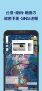
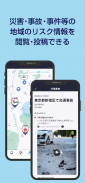
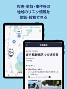
자연 재해에 더해, 교통 사고나 사건 등 지역의 리스크 정보도 공개하고 있습니다.또, 피난 지시등 재해시의 긴급 정보나, 강우(비)·게릴라 호우의 리스크를 푸시 통지로 알려 드리겠습니다.
=================
여기가 대단해!
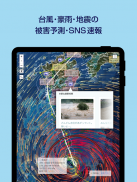
・태풍・호우・지진에 의한 피해 건물수를 예측해, 지도상에 표시합니다.
・지역의 리스크에 관한 SNS 정보를 표시합니다.
・지진이나 풍수해, 폭설 등이 발생했을 때의 어드바이스를 일러스트 첨부로 알려 드리겠습니다.
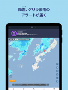
・하강・게릴라 호우 경보를 최대 30분 전(게릴라 호우는 최대 60분 전)에 받을 수 있습니다.
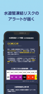
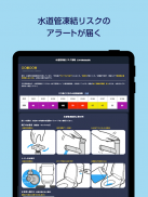
・향후 10일간의 수도관 동결 리스크가 높아졌을 경우에 푸시 통지를 받을 수 있습니다.
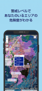
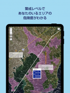
・경계 레벨 3~5 상당의 표시로, 유저의 주변 지역의 위험도를 알 수 있습니다.
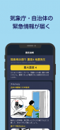
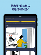
・대우 특별 경보나 피난 지시 등, 재해시의 긴급 정보를 푸시 통지로 받을 수 있습니다.
=================
위험에 대비!
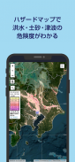
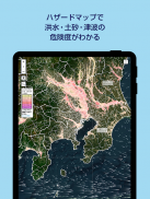
・해저드 맵 정보로 홍수・토사・쓰나미의 위험도를 알 수 있습니다.
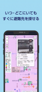
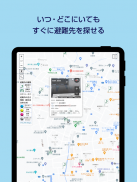
・피난 장소 ・피난소의 위치 정보를 언제라도 확인할 수 있습니다.
=================
일상생활에 도움이 되는 정보가 가득!
・날씨 예보나 생활 지표(세탁 지수나 우산 지수 등)의 정보를 알 수 있습니다.
・배리어 프리 맵으로 배리어 프리 화장실이나 엘리베이터의 장소를 확인할 수 있습니다.
・정체정보를 확인할 수 있습니다.
=================
만일 때도 안심!
・아이오이 닛세이 동화 손보가, 재해된 계약자용으로 사고 접수 창구의 연락처등의 정보를 안내합니다.
被害予測・防災cmap - 버전 3.2.0
(18-03-2025)被害予測・防災cmap - APK 정보
APK 버전: 3.2.0패키지: jp.co.aioinissaydowa.cmap.android


동일 카테고리의 앱


